发表期刊:Ecological Indicators
分区:SCI一区
影响因子:7.4
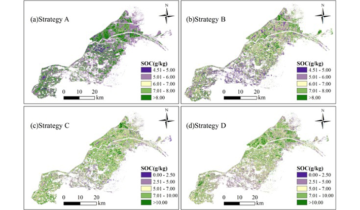
Mapping soil organic carbon (SOC) in coastal farmlands using digital soil mapping (DSM) techniques is vital for assessing soil quality and monitoring the carbon cycle. With the rapid growth of remote sensing data, selecting appropriate environmental covariates is crucial for enhancing DSM accuracy. This study evaluates the effect of different covariate selection strategies on model performance using 128 soil samples collected from Kenli District, Shandong Province. Twenty-seven covariates, including the enhanced vegetation index (EVI), clay index (CI), and salinity index (SI), were derived from remote sensing imagery. Four strategies were applied: Strategy A (all covariates), Strategy B (correlation-based selection), Strategy C (random forest-based selection), and Strategy D (a combination of Strategies B and C). Based on these covariates, four models-Multiple Linear Regression (MLR), Support Vector Regression (SVR), Gaussian Process Regression (GPR), and Random Forest (RF)-were developed to identify the optimal model for SOC mapping. The best model was then used to monitor SOC dynamics in coastal farmlands from 2000 to 2022. Key findings include: (1) Strategy D produced the best results using the RF model, with coefficients of determination (R2) values of 0.79 (training) and 0.69 (validation), root mean square errors (RMSEs) of 1.48 and 1.56 g/kg, and mean absolute errors (MAEs) of 1.12 and 1.01 g/kg, respectively. (2) A negative correlation between soil salinity and SOC was found, with Salinity Index 2 (SI2) showing a correlation coefficient of −0.33. (3) Vegetation, original reflectance, and soil salinity accounted for 35.36 %, 24.32 %, and 18.44 % of the SOC variance, respectively. These results offer valuable insights for assessing land quality and guiding agricultural management in coastal areas.